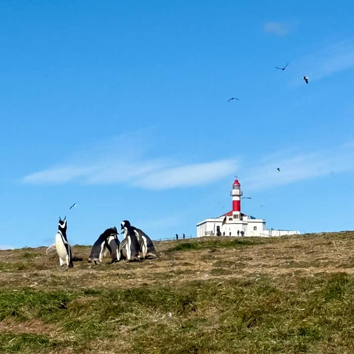
Reached by boat
Magdalena
On the penguin island
- Opened1902
- Tower13.5 m
- InsideCONAF exhibition
Choose your stop
Map of 19 stops
Tap a route first, then a pin or stop, for its note and Google Maps.
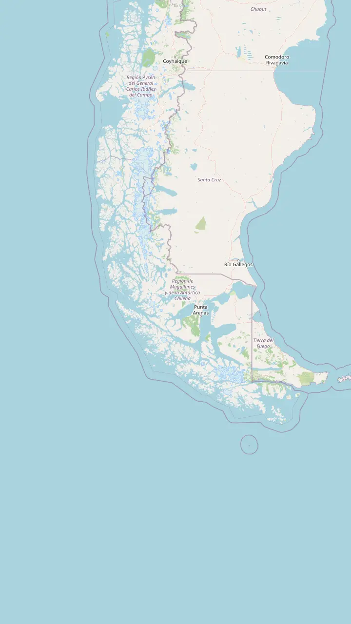
The lighthouse of 1902 that crowns the island walk; rangers keep an exhibition in the old keeper's house.
Google MapsThe first light raised in the Strait area, lit in September 1896 at the western mouth.
Google MapsA cast-iron tower of 14 metres near the Pacific end of the Strait, still run by the Navy.
Google MapsA low light of 1904 that guided ships toward Punta Arenas; today it is lodging.
Google MapsA metal tower of 15 metres from 1901 on the First Narrows, never left without keepers.
Google MapsStone tower of 11 metres built between 1897 and 1900, automated in 1955.
Google MapsPunta Arenas pier named by Sernatur as a departure point for boats to the monument.
Google Maps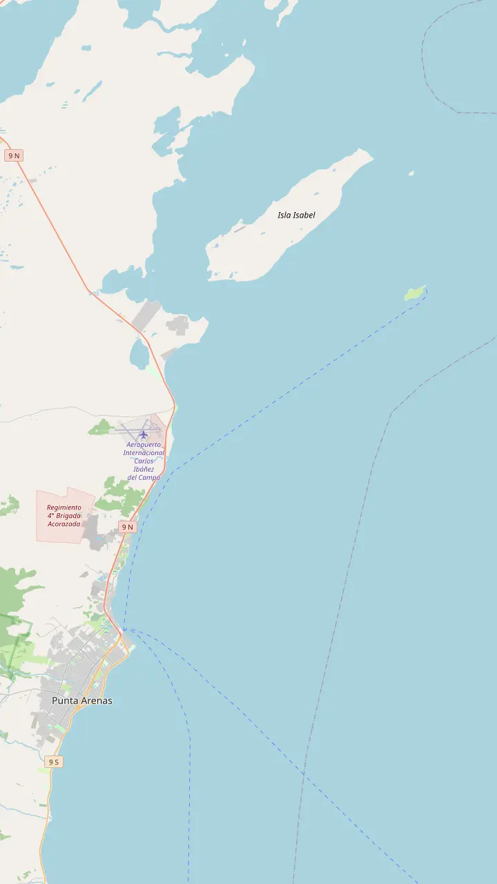
The lighthouse of 1902 that crowns the island walk; rangers keep an exhibition in the old keeper's house.
Google MapsBreeding ground of imperial cormorants and sea lions; landing is banned, so you watch from the boat.
Google MapsThe cape on the mainland that the two islands face, the cape the two islands face; the islands lie 35 km northeast of Punta Arenas.
Google MapsWhere the site tour's speedboat leaves for the islands, after a coach ride of 30 minutes.
Google MapsThe other city pier Sernatur lists for boats to the islands.
Google MapsPunta Arenas pier named by Sernatur as a departure point for boats to the monument.
Google MapsWhere the site tour finishes after the return coach ride.
Google Maps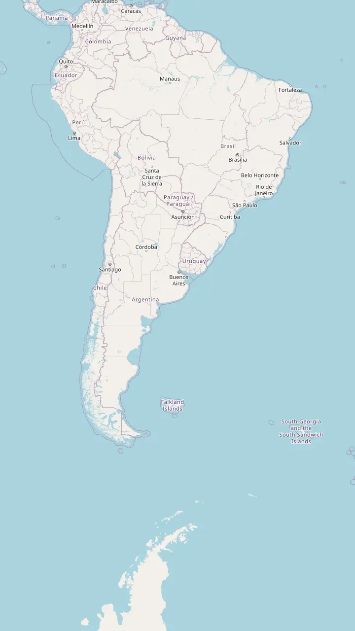
The lighthouse of 1902 that crowns the island walk; rangers keep an exhibition in the old keeper's house.
Google MapsReserve whose islands hold 1,600 pairs on Isla de los Estados and 105,500 on Isla Observatorio.
Google MapsArgentine national park whose colony counts more than 40,000 pairs.
Google MapsArgentine marine park with 13 colonies and 60,000 pairs of Magellanic penguins.
Google MapsChubut reserve that protects the leading mainland colony of the species.
Google MapsRio de Janeiro beach where a young Magellanic penguin was filmed swimming, inside the species' known range.
Google MapsIslets off Chiloé where Magellanic and Humboldt penguins both nest.
Google MapsThe one island of Chile's Humboldt penguin reserve with a trail to see the birds; the Humboldt penguin wears a single chest band.
Google MapsMapping data © OpenStreetMap contributors
The white tower at the end of the penguin trail is a national monument. Here is why it was built, who kept it, how it nearly fell apart and what you can see inside today.
Editorial team, magdalenaislandtour.com · Updated November 12, 2026 · Reading: 8 min
Key facts
The Magdalena Island lighthouse and penguins share the same low hill, but the tower was never built for the birds. It was built for ships. Chile's monuments council explains that the rise of steam navigation turned the Strait of Magellan into a workable passage between the Atlantic and the Pacific.6 Traffic grew further once the Liverpool to Valparaíso service began calling at Punta Arenas.7
The numbers tell the story of a waterway filling up. In 1868 a total of 27 ships anchored at Punta Arenas; by 1892 the count had reached 343 vessels, Chilean and foreign.8,9 After the 1881 boundary treaty with Argentina, Chile held the whole Strait and with it the duty to keep ships safe.10 It was not an abstract duty, as the wreck record of those decades shows, and the coast had few marks a captain could steer by at night.
The losses were real. More than 30 wrecks between 1869 and 1894, most of them costing ships, lives and cargo, alarmed the authorities.11 The answer was a chain of lights. CONAF says the Magdalena tower belongs to a policy of President Jorge Montt to secure navigation on this route, which joined the Atlantic and the Pacific long before the Panama Canal opened.3 Seen from the deck today, the island is a penguin colony; to a captain of that era it was low ground that needed marking.
George Slight's chain
| Lighthouse | First lit or opened | Tower | Today |
|---|---|---|---|
| Evangelistas | 1896 | 12 m, stone | Marks the western mouth |
| Posesión | Built 1897 to 1900 | 11 m, stone and cement | Automated in 1955 |
| Punta Delgada | 1901 | 15 m, metal | Staffed, with a Navy display |
| Magdalena | 1902 | 13.5 m, cylindrical | Monument with a CONAF exhibition |
| San Isidro | 1904 | 7.8 m | Rebuilt as lodging |
| Bahía Félix | 1907 | 14 m, cast iron | Still run by the Navy |
From the monuments council's page for each lighthouse and CONAF's page for the island.19,28,21,27,31,22,30,32,1,2,5,23,26,33,24,29,34
The man behind the tower is George Slight, a Scot who designed lights along Chile's coast. The monuments council credits him with more than 70 lighthouses built for the country's shipping.16 The Strait was where he started. Evangelistas, on an islet 13 nautical miles off the mainland, marks the western mouth and was the first light raised in the area.17,18 Its first stone was laid on 7 November 1895, with the Chilean flag raised over the rock.12
Evangelistas was lit for the first time on 18 September 1896, and its lamp reaches 30 nautical miles across open water.19,20 At the other end of the Strait, the Cabo Posesión light was built between 1897 and 1900 to the same engineer's design.21 Punta Delgada followed on the First Narrows, opening in 1901 in Slight's classic style.22 Magdalena came next, then San Isidro in 1904 and Bahía Félix in 1907, near the Pacific end of the channel.1,23,24
These towers look like relatives, and that is deliberate. The council describes Slight's lighthouses as simple, symmetrical buildings with neoclassical decoration inside and out, from mouldings to sash windows.25 Most combine a tower with a house for the crew who tended the lamp. When you stand under the Magdalena tower, you are looking at one link of a chain of lights planned as a whole along the Strait.
The Magdalena building is modest next to some of its siblings. Its builders used iron, brick and concrete, and the light was inaugurated in 1902 on a cylindrical tower 13.5 metres tall.1,2 Around the tower stood rooms that served as an office, an oil store and a kitchen, plus quarters for the staff and masonry water tanks.2 Everything a small crew needed to keep a lamp burning on an island with little vegetation had to fit inside those walls.
Compared with the other Strait lights, the tower sits in the middle of the range. Punta Delgada has a metal tower of 15 metres, Bahía Félix a cast-iron one of 14 metres, Evangelistas a round stone tower of 12 metres built to shrug off wind and water.30,29,28 Posesión stands 11 metres high in stone and cement, and San Isidro barely rises at 7.8 metres, a low building that hugs its point.27,26
Height mattered less here than position. Magdalena Island faces Cabo Negro across the water, and CONAF measures it at 35 km northeast of Punta Arenas.38 A modest tower on a flat island still makes a clear landmark from the water, and the low island itself was what a navigator had to avoid. Today the same flatness is what lets you see the white tower from the boat long before you land among the burrows.
Plan around the tower
Match the history you want to the outing that gives it.
If I want to stand at the lighthouse
Book a tour that lands on Magdalena
The island walk ends at the tower, inside the hour you have ashore.35,36
If I want to see inside
Ask the guide about the exhibition room
CONAF uses the keeper's house for information and displays.5
If I also want the sea lions
Choose the trip that adds Isla Marta
The site tour lists wildlife viewing at Isla Marta after the island walk.
If I want more navigation history
Add Punta Delgada's Navy display
The Navy shows the story of Strait signalling there.32
If I want the age of discovery
Visit the Nao Victoria Museum
Full-scale replicas include Magellan's ship.37
Lights you can visit
Reached by boat
On the penguin island
Now lodging
South of Punta Arenas
Navy display
First Narrows
For half a century the light needed people. That changed in 1955, when the Magdalena system was automated with a wind-powered generator and a permanent crew was no longer required.14 The same year ended the keepers' era at Cabo Posesión, where the house sheltered the light's crew until the signal was automated.31 Life at these posts was a family affair: at Posesión, families of the 2 keepers who worked the light usually lived in the house together.58
Automation saved labour but left the building exposed. Once the crew left, the Magdalena house stood abandoned for about 30 years and was robbed many times, according to the monuments council.59 Picture an island that fills with nesting birds every summer and empties of people every winter, with a solid house slowly being stripped of anything worth carrying off. The tower kept working while the rooms around it decayed.
Not every Strait light went the same way, which makes the comparison telling. Punta Delgada has always been inhabited and in operation, and the Navy has set up a display there on navigation and maritime signalling in the Strait.43,32 Bahía Félix still belongs to the Navy and is kept in use with staff who run the light and watch the coast.34 Magdalena's fate turned instead on the birds around it, and on a new owner.
A light on the island
1895
The first stone of Evangelistas is laid at the western mouth.12
1902
1914
Until then the Strait was the only passage between the oceans.13
1955
A wind-powered generator automates the light.14
1976
Supreme Decree 556 protects the building.4
1981
The Navy lends it to stop decay and theft.15
The island's protection came before the building's. A decree of 22 August 1966 first made the islands a national tourism park, and in 1982 they were reclassified as a natural monument.60 The lighthouse itself was declared a Historic Monument by Supreme Decree 556 on 10 June 1976, giving the building legal protection of its own.4 Protection now overlaps on the same hill, one law for the wildlife and another for the heritage.
The practical rescue came in 1981, when the Chilean Navy lent the lighthouse to CONAF to stop the decay and stripping of the site.15 The monuments council gives the reason it went to the forest service: CONAF already guarded the island as a protected area because of the great number of penguins that come to nest there each summer.61 The people looking after the birds became the people looking after the building.
The work is still unfinished. CONAF fitted out parts of the house, but the council notes that its restoration has not been completed, and that a project and funding announced in recent years have not yet turned into works.62,63 Meanwhile the house serves the reserve. CONAF lists permanent rangers on the island, an information room and exhibition inside the keeper's house, public toilets and the trail that brings visitors close to the birds.5
Video
Northbound on YouTube · Video data is requested only when you tap play.
The hike is crowned by its historic lighthouse, a National Monument
At the tower
Visitors reach the tower on foot. Sernatur says the walk on Magdalena Island is crowned by its historic lighthouse, and CONAF rates the trail at 1.4 km, about 1 hour in total and easy.35,64 The tour this site recommends lists 1 hour of walking and wildlife viewing on the island inside a 5-hour trip from Punta Arenas. That hour has to cover the path out, the lighthouse and the walk back to the boat, so plan your photos as you go.
The rules shape the visit more than the distance does. CONAF caps a stay on the island at 1 hour, to limit the disturbance to feeding and breeding birds, and asks you to keep at least 2 metres from the penguins.36,55 Entry is only with guides certified by CONAF.65 On the first stretch, about 300 metres from the landing, penguins cross carrying food to their chicks, so slow down there rather than hurrying for the view.66
If the exhibition room is open on your visit, step inside for a few minutes. The island has no food, lodging, electricity or phone service, which makes the old house a reminder of how remote the post once was.57 For many visitors this is what makes the Magdalena Island lighthouse and penguins in Chile a different outing from other colonies: the birds nest around a piece of maritime history, and the guide can tell both stories on the same short loop.
The lighthouse is one stop in a longer history you can trace from the city. Sernatur points to Fuerte Bulnes, founded in 1843 to assert sovereignty over the Strait, and to the ruins of Puerto del Hambre, where a 16th century attempt was made to found the city of Rey Don Felipe.67,68 Together they tell the colonial chapter that came long before any lighthouse was lit, when the Strait was a contested passage rather than a marked shipping lane.
For the age of discovery, visit the Nao Victoria Museum, where life-size copies of historic vessels include the ship Ferdinand Magellan sailed at the start of the first voyage around the world.37 Seeing those replicas after a morning on the island helps you picture how small early ships were in the Strait, and why the Magdalena Island lighthouse and penguins of Patagonia share their hill with a story of navigation rather than of wildlife alone.
Other Slight lights welcome visitors in their own way. San Isidro, opened in 1904 to guide ships toward Punta Arenas, also served as the southern end of the territorial telegraph and has been rebuilt as lodging.23,69,33 Punta Delgada, on the First Narrows crossing, keeps the Navy's display on signalling in the Strait.70,32 Together with Magdalena they let you follow the chain from tower to tower.
FAQ
It was inaugurated that year, raised in iron, brick and concrete.1
CONAF gives the trail as 1.4 km and 1 hour in total, rated easy.64
It was declared a Historic Monument by Supreme Decree 556 on 10 June 1976.4
Sources
Further reading
Penguins in the Strait of Magellan? Ask a real person.